Trip Report: Packrafting the Middle Fork of the Flathead River
Dates: June 27th – July 1st, 2019
Section: Schafer Meadows to Paola Access Area
Length: 38 miles
Flow: 4,300 – 3,400 cfs @ MF Flathead West Glacier Gauge
Backstory
Packrafting has always interested me, but it wasn’t until I won an AIRE BAKraft at Gauley Fest last year that I seriously considered putting a lightweight river trip together. Yes, I know a BAKraft isn’t a true packraft but the portable size and lighter weight lend it to the same purpose. I had previously used IKs on the Tatshenshini and Nahanni, so I knew how much gear they could haul, and I was excited to put my new craft to use on a remote stretch of river.
With a few ideas in mind I reached out to Thor at Alpacka Raft, and he suggested this stretch. The Middle Fork of the Flathead had never been on my radar before, but a quick Google revealed a gem of a river that actually inspired the Wild and Scenic Rivers Act back in 1968. Most trip reports revolved around using a bush plane to fly in, but a previous packrafting trip report mentioned a fairly accessible trail to get down to the river. I only had a week off to attempt the trip, but a small crew came together with Kristen Bryson and Zane Randell. Kristen guided with me at Northwest Rafting and I knew Zane through my time at Colorado College. None of us had really done a packrafting trip before, but this seemed like the perfect opportunity to see what it was all about!
Day 1 – Hike in via Morrison Creek Trail (#154)
Note: here’s the GPS information for the hike if you’re interested.
The trip got off to an interesting start as we drove out of Missoula with hail pelting our car and two days of solid rain in the forecast. Our plan was to drive up Highway 2 to just beyond Essex, and then branch off on Skyland Rd to get the Morrison Creek Trailhead (Trail #154). We slept at the trailhead, and awoke to more rain as predicted. We were joined by two groups at the trailhead: a small group of rafters hiking in to meet the party, and a pair of horsepackers preparing for a fishing trip down to Schafer. While talking to the rafters we learned that flights into Schafer are only around $400. Tempting, but that would make things all too easy.
In an effort to fully embrace the packrafting lifestyle I drove down to the Essex Creek takeout, enjoyed the last steamy minutes of a warm car, and then threw on a rain jacket to hitch 17 miles back up to Skyland Road. After a surprisingly long time I ended up getting picked up by a native from Whitefish who was currently on her way to buy a goat after her previous one was mauled by a mountain lion. You really can’t make that up. From there it was a nice 9 mile run to the trailhead where we put on our backpacks and I realized I was far from perfecting the art of lightweight packrafting.

A couple of stoked people, and a few very heavy backpacks.
The weather cycled between sun and rain throughout the day as we hiked the 14 miles down to Schafer Meadows. The trail is straightforward and mostly all downhill, although it was pretty slippery following the mud tracks of the mules. We crossed Morrison Creek multiple times, and it was almost boatable, but we figured it would be worth maximizing our river miles and hiking all the way to Schafer. In characteristic fashion the rain picked up again just as we waddled into Schafer, and we set up a hasty camp at the river’s edge. All of those pictures in the Missoula airport of happy people fly fishing with bluebird skies? Lies. I was also very glad to have a full drysuit for the trip.

One of the many crossings of Morrison Creek. Floatable, eh?
Day 2 – Schafer Meadows to Castle Creek

Checking out the Schafer Meadows airstrip with low-hanging morning fog.
The morning started with low fog and a fascinating walk around the airstrip and Schafer Meadows ranger station. The airstrip is massively long at 3,500 feet and the bush planes need less than half of it to take off comfortably. Check out this narrated video of a windy flight into the meadows. After seeing two flights come in within the hour, I realized that the river might be a bit busier than anticipated. Looking at the river log it seemed that the river traffic really started to pick up the last week of June, which is historically a sweet spot between good fishing and manageable river flows. I had read that it was only a matter of time until permits would be required for the Schafer to Bear Creek section, but the ranger down there disagreed, saying that river traffic had stayed pretty consistent over the years.
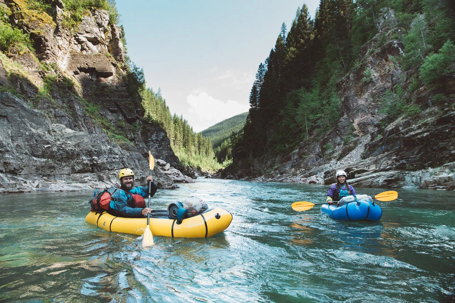
Clouds finally began to lift, and we had sun as we put on the river. The trip suddenly turned into a leisure float once we started to float on the cool, clear water. We put in work the previous day and now it was time to enjoy the fruits of our labor. We began to feel out the capabilities of our boats as we eddy hopped down the river, smiles abounding. Most all rapids were read and run (being able to stand in you boat is very helpful), with two rapids in the Three Forks section needing a quick scout from shore. Miles flew by, especially after Three Forks where fun, splashy Class II just went on forever. I happily let the river carry me along as I sat transfixed by the pristine landscape surrounding me.
Zane launching through a slot in one of the larger rapids of the day.
The water was unusually low for this time of year, and at least one of the rafting parties actually had to de-rig and portage a rapid with some tight slots. Luckily this was a non-issue for our boats. +1 for packrafts. Castle Creek was the popular campsite on this stretch, and two other parties camped in the vicinity that night, but there was plenty of space for everyone.
Day 3 – Castle Creek to Spruce Creek

A view of Castle Lake, sitting high above the MF Flathead.
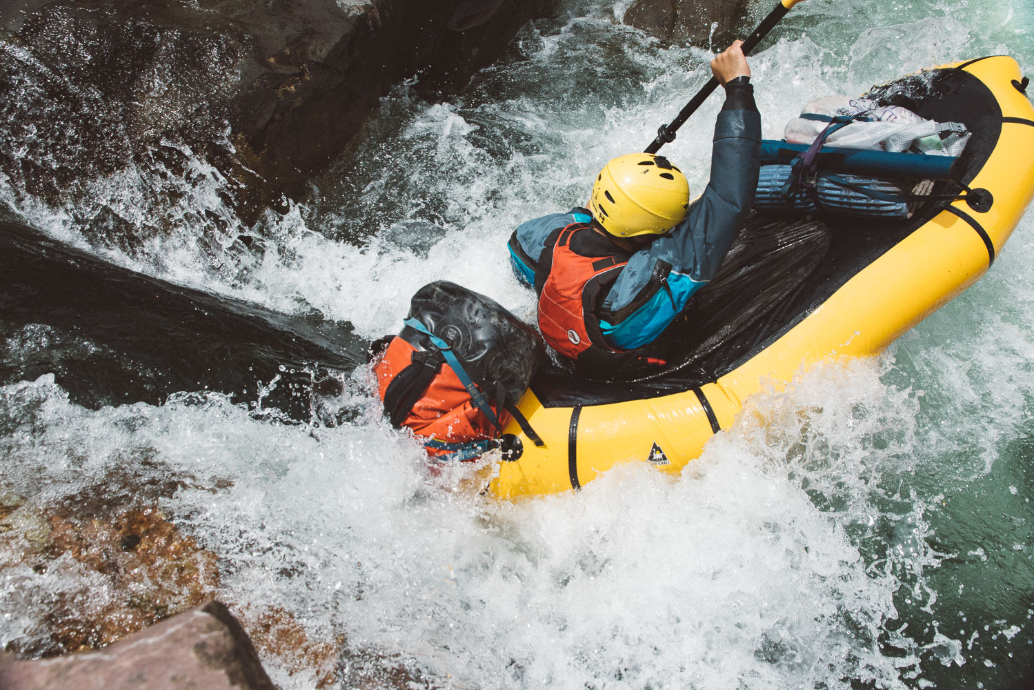
We took a hike from camp up to Castle Lake in the morning where we saw tons of bear scat, but no bears. I highly suggest checking out the lake as it is one of the few established “side hikes” on the river. Another party also had great luck fishing for dinner up there. The river gradient continued through this section with Spruce Park being the highlight of the day. Every river has a certain rapid in its lore, and for the MF Flathead that’s the Spruce Park section.

A view downstream from the first rapid in Spruce Park.
It’s hard to tell where this section starts, but you’ll pass by a cabin on river right which is most visible when looking upstream. From there it’s just a mile downstream to the first rapid which you’ll easily recognize by the horizon line. The walls come together in a tight canyon here, and the crux of the rapid is a move left or right around a set of undercut rocks in center. The move was straightforward at these levels, but a paddle memorial on river left gave a healthy amount of respect for the river before running it. The rest of Spruce Park was straightforward and boat scoutable, so we took in the numerous side-stream waterfalls and steep canyon walls as the sun started to dip below the horizon. We ended up at a beautiful camp just above Spruce Creek where the walls started to open up again, placing us just a few miles above Bear Creek.

Kristen picking her way down a rapid in Spruce Park.
Day 4 – Spruce Creek to Goosenecks above Paola

Zane floating along the roadside section below Bear Creek.
Our last full day on the water was full of lounging. There weren’t really any notable rapids between camp & Paola, and the swift current made the miles pass quickly. The trip started with some true Type II fun with the rainy hike in, and each day got progressively more relaxing after that. I suppose it’s never bad to end on an easy, good note!
We passed Bear Creek after just an hour on the water where we were reacquainted with highways & the numerous raft trips launching on the day section. Our packrafts definitely stood out on this stretch, and we got quite a few questions on our trip as we lazily floated down. While the Bear Creek to Paola Section is considered “roadside” it still retains a remote feel, and the river is just as beautiful. We even had the pleasure of viewing two mountain goats at a lick on the river banks. We got out at Essex to check on our car which happened to be dead, jumped it, and decided to drive it down to Paola to extend our river miles. After that detour we floated down to a long sandy beach in the goosenecks just above Paola and soaked in our final night on the river.

The goats were a popular sight along this day float.
Bottom Line
It’s appropriate that the Wild and Scenic Rivers Act originated with the Middle Fork of the Flathead, as the river truly embodies those two qualities. The rapids are fun, and the continuous gradient makes miles pass quickly, but gnarly whitewater certainly isn’t the draw to this river. Access to the river was fairly easy with the drive and hike it, but the river retains a very remote feel once you’re floating down it. The water quality is also unbelievable, and you’ll likely end up mesmerized as you stare at the smooth cobbles just below the surface. The MF Flathead seems to be most popular as a world-class fly fishing raft trip. I’m partial to smaller craft such as inflatable kayaks and pack rafts for wilderness runs like this as they offer more flexibility with water levels, and this came in handy with the unusually low water this year. Rafts can certainly scrape down at lower levels, but as one of the local guides put it: “You’ll be Lewis and Clarkin’.”
If you’re looking into planning a trip on the MF Flathead, then make sure to check out the regulations and resources linked below. Questions? Post below in the comments!
Resources